Тест по човекът и обществото - 3 клас

- 1.
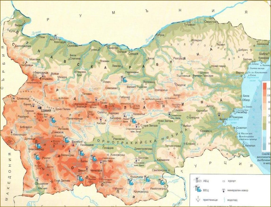
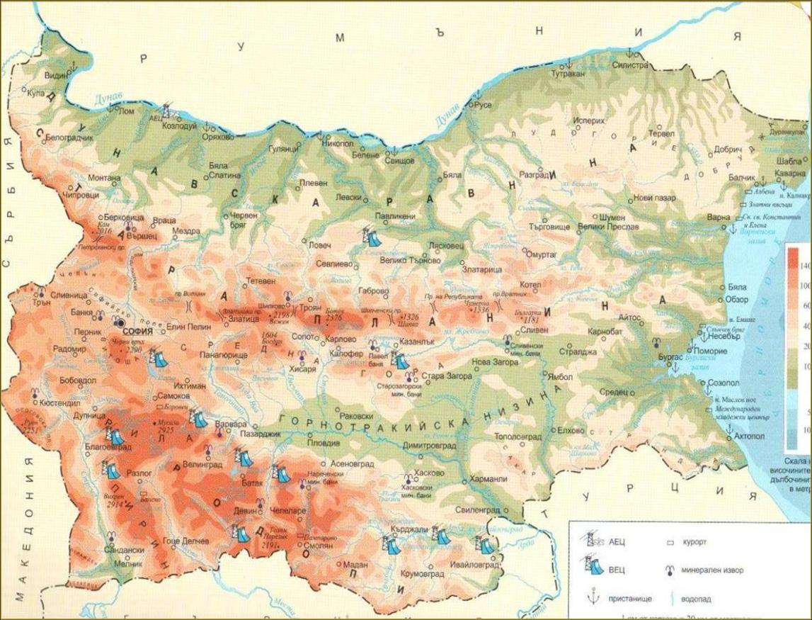
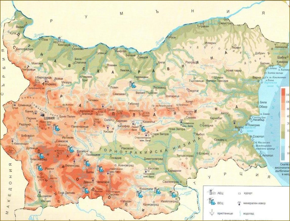
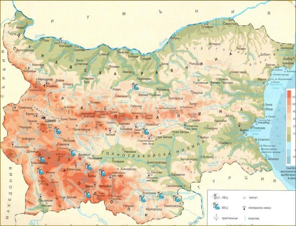
България е разположена на континента Европа, Балкански полуостров. Нейни съседни страни са :
- A.
Румъния, Гърция, Турция, Сърбия, Македония
- B.
Румъния, Гърция, Турция
- C.
Турция, Сърбия, Македония
- D.
Румъния, Гърция, Турция, Сърбия
- E.
Гърция, Турция, Сърбия, Македония
Correct Answer
A. Румъния, Гърция, Турция, Сърбия, МакедонияExplanation
Bulgaria is located on the European continent, specifically on the Balkan Peninsula. Its neighboring countries are Romania, Greece, Turkey, Serbia, and Macedonia.Rate this question:
-
- 2.
Кои са основните посоки на картата?
- A.
юг, изток, северозапад
- B.
югоизток, северозапад, изток, юг
- C.
изток, запад, север, юг
- D.
запад, югоизток, изток, запад
- E.
изток, запад, север, югозапад
Correct Answer
C. изток, запад, север, югExplanation
The correct answer is "изток, запад, север, юг" which translates to "east, west, north, south" in English. This answer correctly identifies the main directions on a map.Rate this question:
-
- 3.
Кои три цвята се използват в природната карта?
- A.
син, кафяв, жълт
- B.
зелен, кафяв, син
- C.
червен, жълт, зелен
- D.
жълт, оранжев, червен
- E.
син, зелен, жълт
Correct Answer
B. зелен, кафяв, синExplanation
The correct answer is "зелен, кафяв, син" because these three colors are commonly found in natural landscapes. Green represents vegetation, brown represents earth or soil, and blue represents bodies of water such as rivers or lakes. These colors are often used in maps to accurately depict the natural features of an area.Rate this question:
-
- 4.
За какво служи картата?
- A.
за изучаване на природни обекти
- B.
за определяне местоположението на родното мяст, на ппланините, на равнините, градове, природни богатства и др
- C.
за означаване на планини и равнини
- D.
за откриване на обозначени природни богатства
- E.
за екскурзия
Correct Answer
B. за определяне местоположението на родното мяст, на ппланините, на равнините, градове, природни богатства и дрExplanation
The map is used to determine the location of one's homeland, mountains, plains, cities, natural resources, and more.Rate this question:
-
- 5.
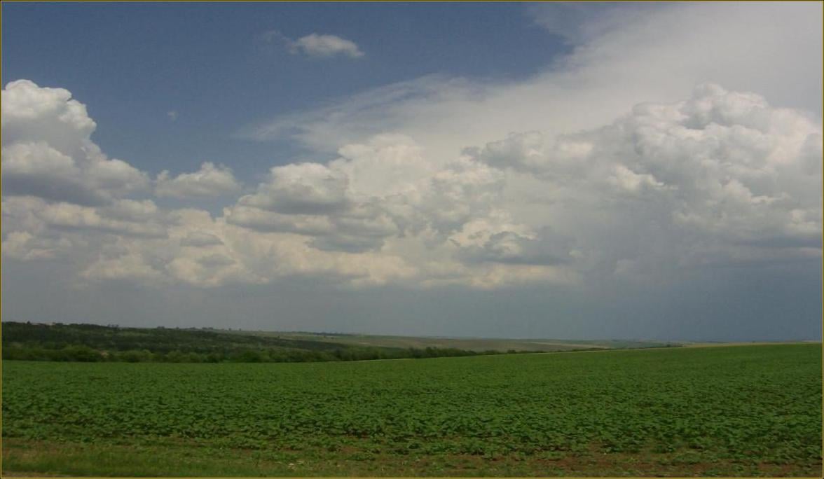
Какво е равнина ?
- A.
обширни пространства на сушата с равна повърхност
- B.
ниски земни части
- C.
земна повърхност с било
- D.
суша
- E.
земна част, обозначена със син цвят на картата
Correct Answer
A. обширни пространства на сушата с равна повърхностExplanation
The correct answer is "обширни пространства на сушата с равна повърхност" which translates to "extensive areas of land with a flat surface". This answer accurately describes a plane as a large, flat area of land. The other options, such as "low parts of the earth" or "land surface with water", do not accurately define a plane.Rate this question:
-
- 6.
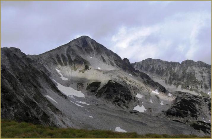
Какво е планина?
- A.
част от земната повърхност, която се издига високо над околните равнини и низини
- B.
част от повърхнина
- C.
равна павърхност
- D.
низина
- E.
обширно пространство от сушата с равна повърхност
Correct Answer
A. част от земната повърхност, която се издига високо над околните равнини и низиниExplanation
A mountain is a part of the Earth's surface that rises high above the surrounding plains and lowlands.Rate this question:
-
- 7.
Какво е низина?
- A.
условен знак върху картата
- B.
най- ниските заравнени пространства
- C.
посока на света
- D.
високи земни повърхности
- E.
суша с равна повърхност
Correct Answer
B. най- ниските заравнени пространстваExplanation
The correct answer is "най- ниските заравнени пространства" which translates to "the lowest leveled spaces". This answer is the most appropriate because it directly translates to the term "низина" which means "lowland" or "low-leveled area". The other options do not accurately describe the concept of "низина".Rate this question:
-
- 8.
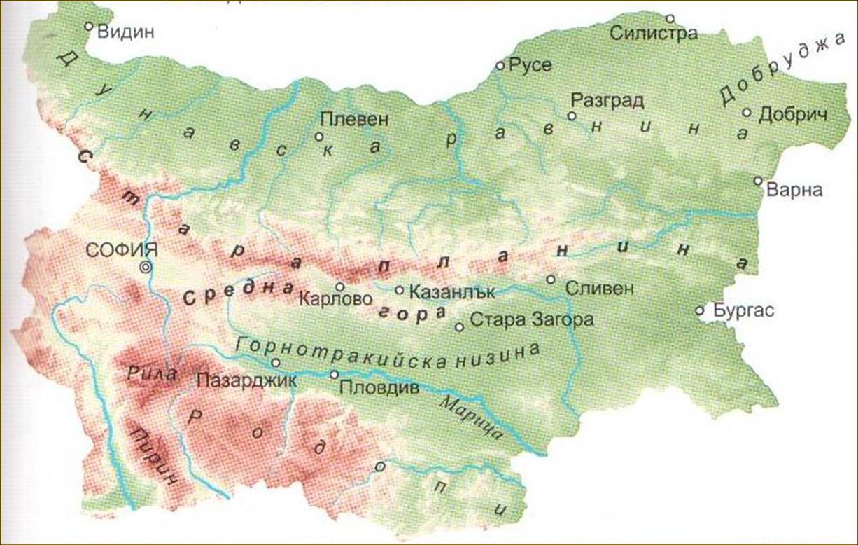
Коя планина е най- дългата в България?
- A.
Рила
- B.
Пирин
- C.
Стара планина
- D.
Родопи
- E.
Витоша
Correct Answer
C. Стара планинаExplanation
Стара планина е най-дългата планина в България.Rate this question:
-
- 9.
Какво включва повърхнината на България?
- A.
реки и равнини
- B.
полета и планини
- C.
равнините, низините, планините, полетата
- D.
реките и моретата
- E.
полета и низини
Correct Answer
C. равнините, низините, планините, полетатаExplanation
The surface of Bulgaria includes plains, lowlands, mountains, and fields.Rate this question:
-
- 10.
Коя е най-високата планина в България?
- A.
Витоша
- B.
Рила
- C.
Родопи
- D.
Стара планина
- E.
Пирин
Correct Answer
B. РилаExplanation
The correct answer is Рила. Рила is the highest mountain range in Bulgaria, with its highest peak, Musala, reaching 2,925 meters above sea level. It is known for its stunning landscapes, including glacial lakes, deep valleys, and diverse flora and fauna. The Rila National Park, located in this mountain range, is also a popular tourist destination.Rate this question:
-
- 11.
Къде е разположена Дунавската равнина?
- A.
в южна България
- B.
между река Дунав и Стара планина
- C.
в югоизточна България
- D.
до Черно море
- E.
до Пирин
Correct Answer
B. между река Дунав и Стара планинаExplanation
The correct answer states that the Danube Plain is located between the Danube River and the Balkan Mountains. This is a geographically accurate statement as the Danube Plain is a low-lying region in Bulgaria that stretches between these two natural features. The Danube River forms the northern border of the plain, while the Balkan Mountains define its southern boundary. This region is known for its fertile agricultural land and is an important economic and cultural area in Bulgaria.Rate this question:
-
- 12.
Къде се намира Горнотракийската низина?
- A.
в северна България
- B.
в южна България
- C.
на североизток от София
- D.
до Черно море
- E.
до град Русе
Correct Answer
B. в южна БългарияExplanation
The correct answer is "в южна България" (in southern Bulgaria). This is because the question is asking about the location of the Gornotrakiyska Nizina (Thracian Plain), and it is located in the southern part of Bulgaria.Rate this question:
-
- 13.
Къде се намират градовете Русе, Силистра, Видин, Лом?
- A.
на Черно море
- B.
в Добруджа
- C.
по река Дунав
- D.
в Горнотракийкската низина
- E.
в Румъния
Correct Answer
C. по река ДунавExplanation
The cities of Ruse, Silistra, Vidin, and Lom are located along the Danube River.Rate this question:
-
Quiz Review Timeline +
Our quizzes are rigorously reviewed, monitored and continuously updated by our expert board to maintain accuracy, relevance, and timeliness.
-
Current Version
-
Mar 22, 2023Quiz Edited by
ProProfs Editorial Team -
Nov 21, 2009Quiz Created by
Pf118
 Back to top


